Bridging the gap: mapping wood supply and demand in Europe with spatial accessibility analysis

Forests are vital providers of ecosystem services, and wood is one of the most in-demand resources. But how well do supply and demand align across Europe? Researchers are exploring regional imbalances of supply and demand through spatial accessibility analysis to better understand the state and use of multiple ecosystem services.

All Earth’s ecosystems provide us with countless benefits, commonly known as ecosystem services. Among those, forests play a critical role, supplying a wide range of services that support human welfare and wellbeing. Wood is one of the key forest ecosystem services, characterized by growing global demand driven by various factors, including economic development and industrialization.

Mapping the state of ecosystem services is one of the objectives of the EU Biodiversity Strategy. To meet this goal, it is important not only to understand where ecosystem services are produced but also to assess the levels of demand across different regions. While regional and national statistical comparisons provide valuable information, combining them with spatial data analysis can contribute to a more comprehensive understanding of the relationship between supply and demand.

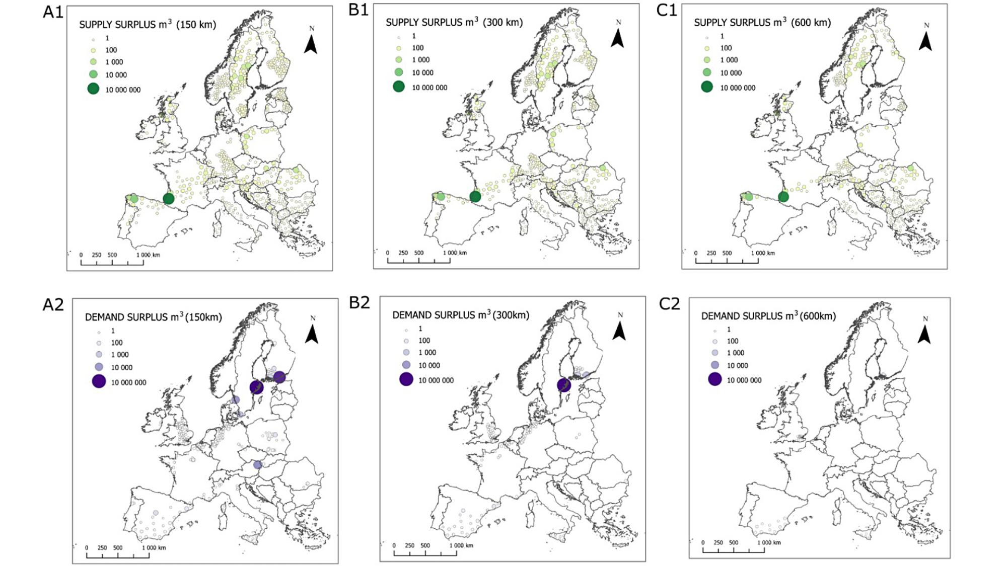
Picture of the main results of the study.
Wood ecosystem service supply and demand surpluses after spatial accessibility analysis for distances of 150 km (A), 300 km (B) and 600 km (C) for average annual supply and demand values between 2008 and 2018 in cubic meters (m3 per 10 years).

Why mapping supply and demand matters

Ecosystem services are largely produced and consumed in different locations. To assess the balance between supply and demand from a geographic perspective, we need information about the specific locations where supply and demand occur. A spatial accessibility model that includes the characteristics of the transport system and the potential flow of materials through the transport network can address mismatches between supply and demand across different scales.

In our recent study published in the Ecological Indicators journal, we explored the balance of the supply and demand of European wood ecosystem services. We applied a Geographic Information Science-based spatial accessibility methodology to relate the amount of forest resources used locally or regionally by society to the amount of forest resources accessible from the area. This allowed us to identify regions with potential mismatches, such as cities, regions, or nations with high demand but limited access to wood resources.

Key insights from European wood supply-demand analysis

Taking the example of our study, the results reveal that, on average, between 2008 and 2018 in Europe, a balance between the supply and demand for wood ecosystem service can typically be achieved within a transport distance of 600 km. Based on the findings, Europe appears to have enough wood resources to meet domestic demand, with some surplus available for international trade. While the spatial accessibility of wood-related ecosystem services appeared to be relatively high during the period studied, considerations remain regarding equitable availability, long-term sustainability, and potential implications of changes in trade patterns. The spatial accessibility mapping framework provides a useful approach for identifying areas where levels of supply and demand are not matched.

Beyond wood: the future of ecosystem service mapping

To support a more comprehensive understanding of the sustainable use of ecosystem services, it is also important to examine the balance between the supply and demand of other forest-based services. In addition to wood, forests offer a variety of services such as recreation, berry picking, hunting, or carbon sequestration – each with its own supply and demand dynamics.

By considering these services collectively, we can better identify potential trade-offs and make more informed decisions about the future of forest resource management. Spatial accessibility analysis can be applied at local, regional, continental, or even global scales, opening new opportunities for optimizing consumption patterns and promoting sustainable use of our vital ecosystems.

Authors

Anita Poturalska
Doctoral Researcher
Geography
University of Oulu

Anita Poturalska is a Doctoral Researcher in the Geoinformatics Research Group of the Geography Research Unit, University of Oulu. Her PhD project focuses on the multiscale assessment of ecosystem services, with a broader interest in understanding the dynamic relationship between people and the environment. She explores human-environment relationship, using geospatial methods to support sustainability-focused decision-making. Her ultimate goal is to translate her research into actionable insights for building a more sustainable and resilient future.

Research Director, Regional Excellence (REx)
University of Oulu, Kerttu Saalasti Institute
University of Oulu

Ossi Kotavaara is a Research Director and Adjunct Professor at the Kerttu Saalasti Institute. His main research interests include geoinformatics, regional science, as well as transport and economic geography. His work is analytically grounded in applying and developing GIS methods to explore, plan, and optimize processes and structures within a geographic context.

Postdoctoral Researcher
University of Oulu, Kerttu Saalasti Institute
University of Oulu

Terhi Ala-Hulkko is a Postdoctoral Researcher in Aalto University and University of Oulu. She is a geographer specializing in ecosystem services and human–nature relationships across spatial scales. Her research uses GIS-based accessibility analysis to investigate how people access different ecosystem services and to evaluate potential negative impacts that ecosystems may have on people. Her current research revolves around understanding how people access and use different types of ecosystem services in urban environments, and how they can reach these sites using sustainable transport modes.